 plate: 5 7/8 x 8 7/8 (15 x 22.5 cm); sheet: 14 15/16 x 12 3/8 (38 x 31.5 cm)
Chris Burden. Untitled from Coyote Stories. 2005
Chris Burden。无题于《狼的故事》。2005-
plate: 5 7/8 x 8 7/8 (15 x 22.5 cm); sheet: 14 15/16 x 12 3/8 (38 x 31.5 cm)
Chris Burden. Untitled from Coyote Stories. 2005
Chris Burden。无题于《狼的故事》。2005-
 plate: 8 7/8 x 5 7/8 (22.5 x 15 cm); sheet: 14 15/16 x 12 3/8 (38 x 31.5 cm)
Chris Burden. Untitled from Coyote Stories. 2005
Chris Burden。无题于《狼的故事》。2005-
 plate: 10 3/4 x 8 9/16 (27.3 x 21.7 cm); sheet: 14 15/16 x 12 3/8 (38 x 31.5 cm)
Chris Burden. Untitled from Coyote Stories. 2005
Chris Burden。无题于《狼的故事》。2005-
 plate: 10 3/4 x 8 9/16 (27.3 x 21.7 cm); sheet: 14 15/16 x 12 3/8 (38 x 31.5 cm)
Chris Burden. Untitled from Coyote Stories. 2005
Chris Burden。无题于《狼的故事》。2005-
 plate: 10 3/4 x 8 9/16 (27.3 x 21.7 cm); sheet: 14 15/16 x 12 3/8 (38 x 31.5 cm)
Chris Burden. Untitled from Coyote Stories. 2005
Chris Burden。无题于《狼的故事》。2005-

材质 : Oil on canvas
图片文件尺寸 : 4859 x 3695 px
Jonathan Monk-Near Death Experienced (after Jack Goldstein after Chris Burden after), 2006.
乔纳森·蒙克-《濒死体验》(杰克·戈德斯坦之后,克里斯·伯登之后),2006年。

图片文件尺寸 : 2393 x 3660px
Jan Le Witt的“使用香克斯”小马。尽可能步行,减轻战争给交通带来的负担-Jan Le Witt
Use Shanks Pony. Walk when you can and ease the burden which war puts on transport--Jan Le Witt (英国, 1907–1991)

图片文件尺寸 : 2048 x 2624px
菲利普·阿莱克修斯·德·拉斯洛(Philip Alexius de László)《威廉·伯登夫人,A.M.》-Philip Alexius de László
Mrs. William Burden, A. M. (née Margaret Livingston Partridge)--Philip Alexius de László (Hungarian, 1869–1937)
![America. Amsterdam: [1628].](http://www.minghuafuzhi.com/2022/12/02140048903.jpg)
图片文件尺寸 : 5183 x 4525px
:America. Amsterdam: [1628].
Hand-colored engraved map, 384 x 507 mm. French text on verso, seas decorated with ships and sea creatures and large inset scene of Brazilian natives. Vertical creases alongside centerfold. Framed.
A fine decorative map from the Golden Age of Dutch Cartography. Hondius used \"various scenes taken from the earlier volumes of de Bry\'s Grand Voyages to adorn the whole. Particularly notable is the native Brazilian scene illustrating the method used to make a local beverage.\" Burden Mapping of North America 150.
无 题 美国阿姆斯特丹:[1628]。
![Insulae Americanae in Oceano Septentrionali, cum Terris adjacentibus. Amsterdam: [1635 or later].](http://www.minghuafuzhi.com/2022/12/02143946193.jpg)
图片文件尺寸 : 4619 x 4351px
BLAEU, WILLEM. 1571-1638.:Insulae Americanae in Oceano Septentrionali, cum Terris adjacentibus. Amsterdam: [1635 or later].
Engraved map of the Caribbean, hand-colored in outline with elaborately decorated cartouches, 390 x 540 mm. Matted and framed.
Burden Mapping of North America 242.
蓝色,威尔。1571-1638. 西太平洋上的美国岛屿及其邻近国家。阿姆斯特丹:[1635年或更晚]。

图片文件尺寸 : 5415 x 4990px
JAILLOT, ALEXIS HUBERT. C.1632-1712.:Amerique Septentrionale Divisée en Ses Principales Parties. Paris: c.1726.
Hand-colored engraved map of North America showing California as an island, 490 x 600 mm. Elaborately decorated cartouches. Soft crease down center fold. Matted and framed.
Burden Mapping of North America 700, State 2; McLaughlin 113.
监狱,亚历克斯·休伯特。C、 1632-1712年。 北美分为主要部分。巴黎:约1726年。
图片文件尺寸 : 4455 x 4726px
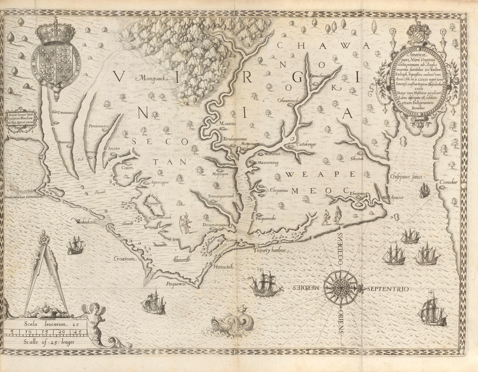
BRY, THEODOR DE. 1528-1598; AND THOMAS HARIOT.:Admiranda Narratio Fida Tamen, de Commodis et Incolarum Ritibus Virginiae. Frankfurt: Johann Wechel, 1590.
Folio (332 x 240 mm). Engraved title (first issue, see below), engraved arms on dedication leaf, double-page engraved map of Virginia in first state, engraved plate of Adam and Eve in first state with inscription \"Iodocus a winghe in Theodore de Bry fe.\" and 27 engraved plates after John White. Late 19th-century red morocco gilt by \"Bradstreet\'s for J. Comly MacCoy,\" gilt edges. Some light mostly marginal staining. Provenance: J.C. MacCoy (booklabel and binding).
FIRST EDITION, MOSTLY FIRST ISSUE (see below) OF THE FIRST VOLUME OF DE BRY\'S GREAT VOYAGES, BEING THOMAS HARIOT\'S DESCRIPTION OF VIRGINIA, and published during De Bry\'s lifetime. Thomas Hariot accompanied the 1585 expedition to Roanoke funded by Sir Walter Raleigh and acted as a translator. He had learned Carolina Algonquian from two Roanoke chiefs brought to England by Raleigh the year before. His account is a very encouraging one as the mysterious disappearance of Roanoke colony was not reported in Europe until John White, the expedition artist and mapmaker, returned in 1590.The 23 illustrations to the text, which are after John White\'s drawings, are by far the most important visual record of New World natives as first encountered by the English colonists. Also included is the highly important double-page map, the first map to identify Chesapeake Bay and \"the first printed map of this degree of detail and accuracy for any part of the present area of the United States\" (Cumming). It was dubbed by Burden \"one of the most significant cartographical milestones in colonial North American history ... the most accurate map drawn in the sixteenth century of any part of that continent. It became the prototype of the area until long after James Moxon\'s map in 1671... This is the first map to focus on Virginia (now largely North Carolina), and records the first English attempts at colonization in the New World. First issue engraved title as Church 140a, the plate not worn but without the printed \"cum gratia et privilege...\" at the bottom of the title panel. Map and most plates in first issue (plates 4, 7, 11, 12 second issue). D6 is a blank and genuine. Burden 76 (first state); Church 140; Cumming Southeast 12-13; European Americana 590/31; Sabin 8784.
布莱,西奥多·德。1528-1598年托马斯·哈里奥特。 弗吉尼亚州商业和国际贸易部。法兰克福:约翰·韦切尔,1590年。
下载布莱,西奥多·德。1528-1598年托马斯·哈里奥特。 弗吉尼亚州商业和国际贸易部。法兰克福:约翰·韦切尔,1590年。大图
![Nova Belgica et Anglia nova. Amsterdam: [1642 or later].](http://www.minghuafuzhi.com/2022/12/02141254198.jpg)
图片文件尺寸 : 4438 x 5159px
:Nova Belgica et Anglia nova. Amsterdam: [1642 or later].
Hand-colored double-page engraved map, 388 x 507 mm, Dutch text on verso, decorative cartouche flanked by a native person on each side and surmounted by the Dutch Republic crest, scale bar flanked by mer-children, decorated with three ships, three canoes paddled by natives, a Mohican village, various wildlife including deer, foxes, bears, egrets, rabbits, cranes, turkeys and for the first time on a map beavers, polecats and otters. Framed. Centerfold reinforced on verso, small area of skinning in the Atlantic, but an attractive example.
Blaeu\'s seminal map was the first full printed representation of the manuscript map of Adriaen Block. It is one of the earliest to name Nieu Amsterdam and the earliest to depict insular Manhattan. Burden North America 241.
无 题 新比利时和英格兰阿姆斯特丹:[1642年或更晚]。
图片文件尺寸 : 4279 x 4681px
MÜNSTER, SEBASTIAN. 1489-1552.:Cosmographey, oder beschreibung aller lander ... jetzunder biss auff das M.D.LXIIII. jar vyl gemehret. Basel: Henrichum Petri, 1564.
Folio (312 x 207 mm). 14 double page maps, 41 double-page plans and views (3 extended and folded) in collation; folding table at Ddd3; register bound before the 14 maps. Contemporary panelled pigskin, recently rebacked in morocco, lacking straps, and one clasp from rear board, rubbed. Title page re-margined, and re-inserted on stub, numerous marginal repairs to leaves throughout, only sometimes affecting text, staining; plate, \"Die statt kom in aller Weldt\" (K1-2), stained from censor\'s ink applied to engraving on verso; plate \"Die Statt Heidelberg\" trimmed at outer margin, re-cornered with loss; \"Die Statt Frankfurt\" trimmed at left margin (Ooo4); plate \"Die Statt Wyen...\" trimmed at outer edge (Ppp 2), with loss.
A complete copy of an early edition in German of the book that \"sealed the fate of \'America\' as the name of the New World\" (Burden 12). Münster\'s map of the Americas is the first to show America in its correct continental form, and the first to name the Pacific Ocean. While it first appeared in Münster\'s Geographia in 1540, it was its appearance in the 1544 Cosmographia that crystalized the name \"America\" in the popular lexicon. The hugely popular and influential work was created collaboratively, with Münster reaching out to international scholars to provide information on their localities. Sabin 51390.
塞巴斯蒂安先生。1489-1552. Cosmographey,或所有着陆者的描述,现在咬了M.D.LXIII。jar vyl宝石。巴塞尔:亨利·彻姆·佩特里,1564年。
下载塞巴斯蒂安先生。1489-1552. Cosmographey,或所有着陆者的描述,现在咬了M.D.LXIII。jar vyl宝石。巴塞尔:亨利·彻姆·佩特里,1564年。大图
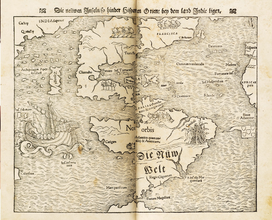
![Brevis Narratio eorum quae in Florida Americae provincia Gallis acciderunt ... Frankfurt am Main: Johannes Wechel for T. de Bry, 1609 [engraved title and colophone dated 1591].](http://www.minghuafuzhi.com/2022/12/02141001114.jpg)
图片文件尺寸 : 4868 x 4335px
BRY, JOHANN THEODOR DE. 1561-1623; and JACQUES LE MOYNE. C.1533-1588.:Brevis Narratio eorum quae in Florida Americae provincia Gallis acciderunt ... Frankfurt am Main: Johannes Wechel for T. de Bry, 1609 [engraved title and colophone dated 1591].
Folio (338 x 220 mm). Engraved title, colored engraved arms on dedication leaf, engraved sectional title \"Indorum Floridam provinciam inhabitantium eicones,\" engraved vignette of Noah\'s Arc on )(3r, ALL COLORED IN A CONTEMPORARY HAND, 42 numbered half-page engravings after Le Moyne above Latin letterpress descriptions, engraved folding map \"Floridae Americae Provinciae recens exactissima descriptio\" (398 x 445 mm), additional leaf \"Mendae quaedam...\" bound in at end. Modern morocco gilt. All leaves mounted on stubs, section title laid down, folding map laid down, trimmed with minor chipping along edges, lacking blank H6, colored leaves slightly shorter, some light browning and staining.
Second Latin edition (most plates in first state, see below) of the second part of de Bry\'s \"Great Voyages.\" This is the foundation book \"of any Florida collection because of its first printing of the Le Moyne narrative. Lawrence Wroth has characterized it as the most informative and satisfactory of all the books on the Huguenot colony in Florida. The fascinating plates of Florida Scenes and life engraved by De Bry after Le Moyne\'s drawings, make this an indispensable Florida items. Le Moyne\'s narrative was first published in French, Paris 1586\" (Streeter). The map was considerable interest: Hondius based his maps of the area in 1606 on this one, \"the atlas in which it occurred was Mercator\'s and his fame was enough to prolong its authority until the Blaeu VIRGINIAE partis australis, c. 1638\" (Burden 79). Plates in first state except 8, 10, 16, and 17. Church 146; Sabin 8784; Streeter 1172.
布里,约翰·西奥多,1561-1623年还有雅克·勒莫恩。约1533-1588年。 布雷维斯·纳拉蒂奥(Brevis Narratio)是美国佛罗里达州位于法国省的人物……美因河畔法兰克福:约翰内斯·韦切尔(Johannes Wechel)为T.de Bry创作,1609年[雕刻的标题和文字标记日期为1591年]。